Back تلال بيركلى ARZ Berkeley Hills CEB برکلی هیلز Persian Collines de Berkeley French Berkeley Hills LLD Berkeley Hills Dutch Berkeley Hills NN Đồi Berkeley Vietnamese
| Berkeley Hills | |
|---|---|
 | |
| Highest point | |
| Elevation | 581 m (1,906 ft) |
| Geography | |
Location of Berkeley Hills in California[1] | |
| Country | United States |
| State | California |
| District | Alameda County |
| Range coordinates | 37°52′58″N 122°14′16″W / 37.88278°N 122.23778°W |
| Topo map | USGS Briones Valley |
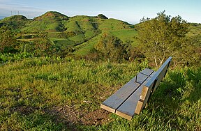
The Berkeley Hills are a part of the East Bay Hills, a range of the Pacific Coast Ranges, and overlook the northeast side of the valley that encompasses San Francisco Bay. They were previously called the "Contra Costa Range/Hills"[2][3] (from the original Spanish Sierra de la Contra Costa), but with the establishment of Berkeley and the University of California, the current usage was applied by geographers and gazetteers. The Berkeley Hills are included as part of the Diablo Range in the United States Geological Survey (USGS) Geographic Names Information System list of GPS coordinates for the latter.[4]
- ^ "Berkeley Hills". Geographic Names Information System. United States Geological Survey, United States Department of the Interior. Retrieved 2009-05-04.
- ^ Engineers, United States Army Corps of (July 28, 1856). "Reports of Explorations and Surveys for a Railroad from the Mississippi River to the Pacific Ocean...1853-54". Archived from the original on July 28, 2022. Retrieved September 7, 2022 – via Google Books.
- ^ "The Atlantic, July 1874". The Atlantic. July 1874. Archived from the original on 2022-08-01. Retrieved 2022-08-01.
- ^ "Diablo Range". Geographic Names Information System. United States Geological Survey, United States Department of the Interior.
© MMXXIII Rich X Search. We shall prevail. All rights reserved. Rich X Search
